Social Studies is interdisciplinary
Within social studies there lies multiple disciplines. The skills learned in these disciplines can become really applicable in other disciplines. Specifically for me, ensuring that my students could understand maps, charts, and graphs was a big push in the classroom. Outside of the classroom I worked to educate teachers of other disciplines how they can use maps in their lessons. Because of social studies interdisciplinary nature, it is able to quite easily interact with just about every single discipline
Maps Across Disciplines
While at Michigan State’s teacher education program I had the opportunity to lead (with two group mates) a professional development session for teachers across the disciplines. My group, being all social studies opted to teach about how teachers can use maps in their classroom. For us, the knowledge of how to use maps, and the benefit they can add was obvious. But for other subjects we found, naturally, many weren’t thinking about using maps in their lessons. We talked about how maps can be used in an English class to map the progression of a story, or in an earth science class to map topics like weather patterns and climates. In teaching students how to read maps, we are instilling a valuable skill to students. We interact with maps constantly, and for some of us, that thought is unconscious, it is just a skill many of us have. What needs to be remembered is that much like all skills using maps well is a learned skill. We must teach students how to read maps, and we must show them that we use maps all the time and in every subject. Our PD focused on the ways in which maps can be used in various disciplines (hence the name) and also ways in which maps can be used to build community in the classroom, and breakup long lessons.
Reading Charts and Graphs
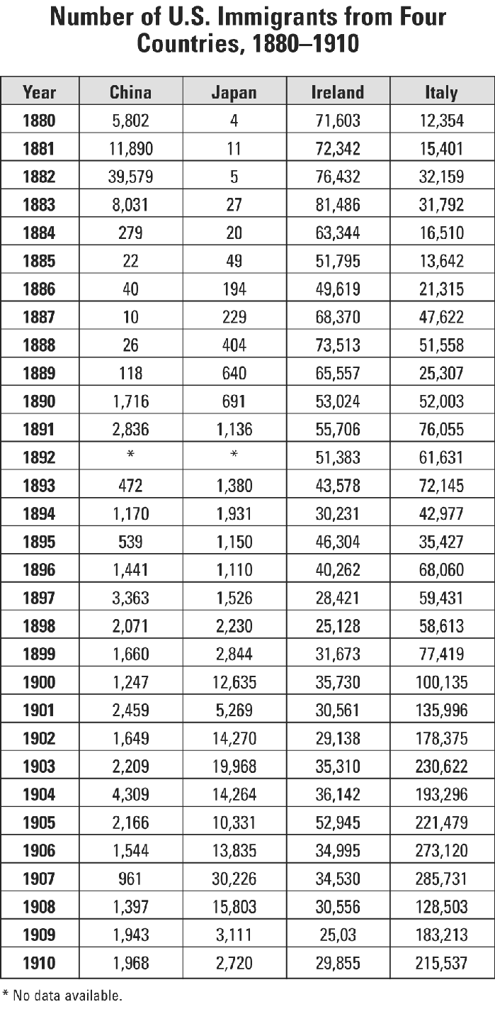
Much as I hope my colleagues in other disciplines are bringing maps into their classroom, I, as a social studies teacher, recognize the important of bringing some concepts from other discipline. Thus, I have found it worthwhile to ensure that my students can read graphs and charts. While a concept from math, graphs and charts nevertheless make a lot of appearances in social studies, and it is really important that our students are taught how to read them. Whether it is US history, or econ both classes make use of graphs and charts. Econ more so than history, as visual representation really a central part of the class. Teaching these skills is certainly more of a challenge for the students in US History. A freshmen class, many of the students are still getting accustomed to the various types of graphs that show up. But nonetheless, including graphs and charts does two things, further strengthens students literacy skills, AND helps deepen their understanding of history. We can’t expect students to just know how to read and understand graphs and charts, it is something that we must teach them how to do! Throughout our units, when applicable we make sure to include graphs and charts. We walk our students through how to read them. After checking for understanding we know that we can use graphs and charts to enhance student understanding. To ensure that this is going well too, we include graphing and chart questions on our tests.
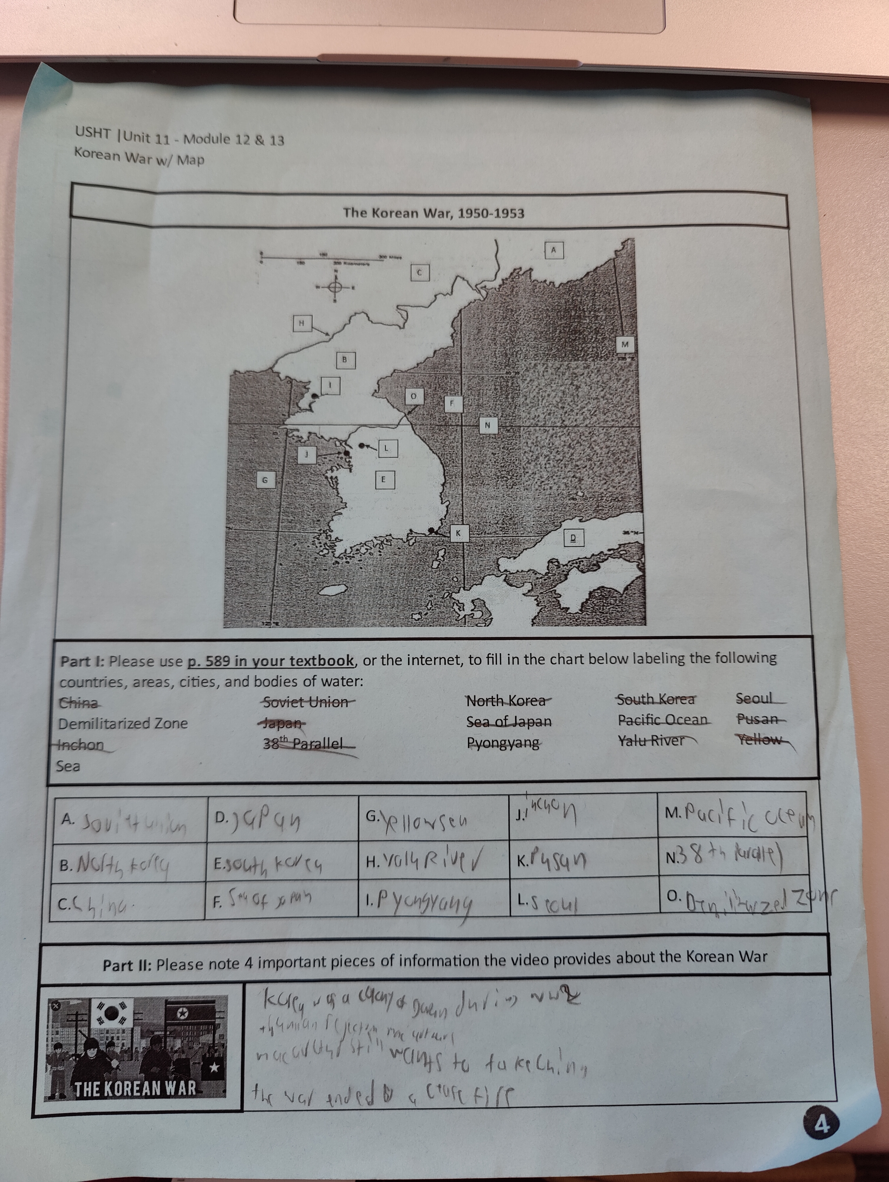
Maps in the classroom
Social studies itself is, in my opinion, a very interdisciplinary subject. While related on the level of being a social science, there are differences in disciplines from history, to geography, political science, and especially political science. Though ninth grade US History isn’t a geography class, it is still incredibly important to me that students have some level of understanding of world geography. Being US History it can be hard sometimes to justify using a world map in the class. Of course, students are made familiar with a map of the US, but when applicable we chose to include as many maps as possible. Students know too, that when we complete a mapping activity in class they should expect a mapping portion on their unit test. Across the board though I have seen students be very successful at the mapping portions on tests. While many students groan when we start a mapping activity, we introduce them in a such a way (usually they are working in pairs or groups) that hopefully makes it more enjoyable, and also easier to comprehend. Our most recent mapping activity, students who would groan seemed far more excited than before, or at the very least more willing to try. Having knowledge of world geography is an incredibly important skill to have while navigating such a social, and interconnected world.